Advanced Road Safety

Transforming Road Safety Through Intelligent Software

Discover a smarter way to conduct Road Safety Inspections and Audits through synchronized video analysis, interactive mapping, infrastructure deficiency tracking, speed and elevation insights, and data-driven support for safer roads.

RSI Viewer standard interface with synchronized video, map, and analysis tools
Explore Our Capabilities

Advanced Road Safety Inspection With RSI Viewer

Experience what makes us exceptional in the road safety industry. Innovative approach, intelligent tools, and comprehensive reporting.

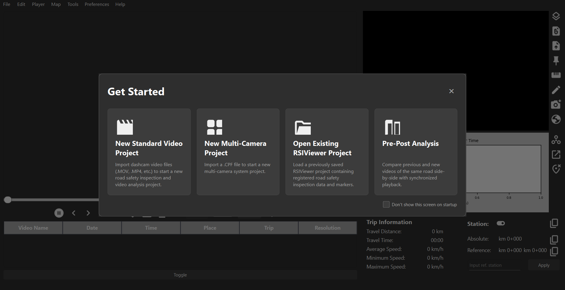
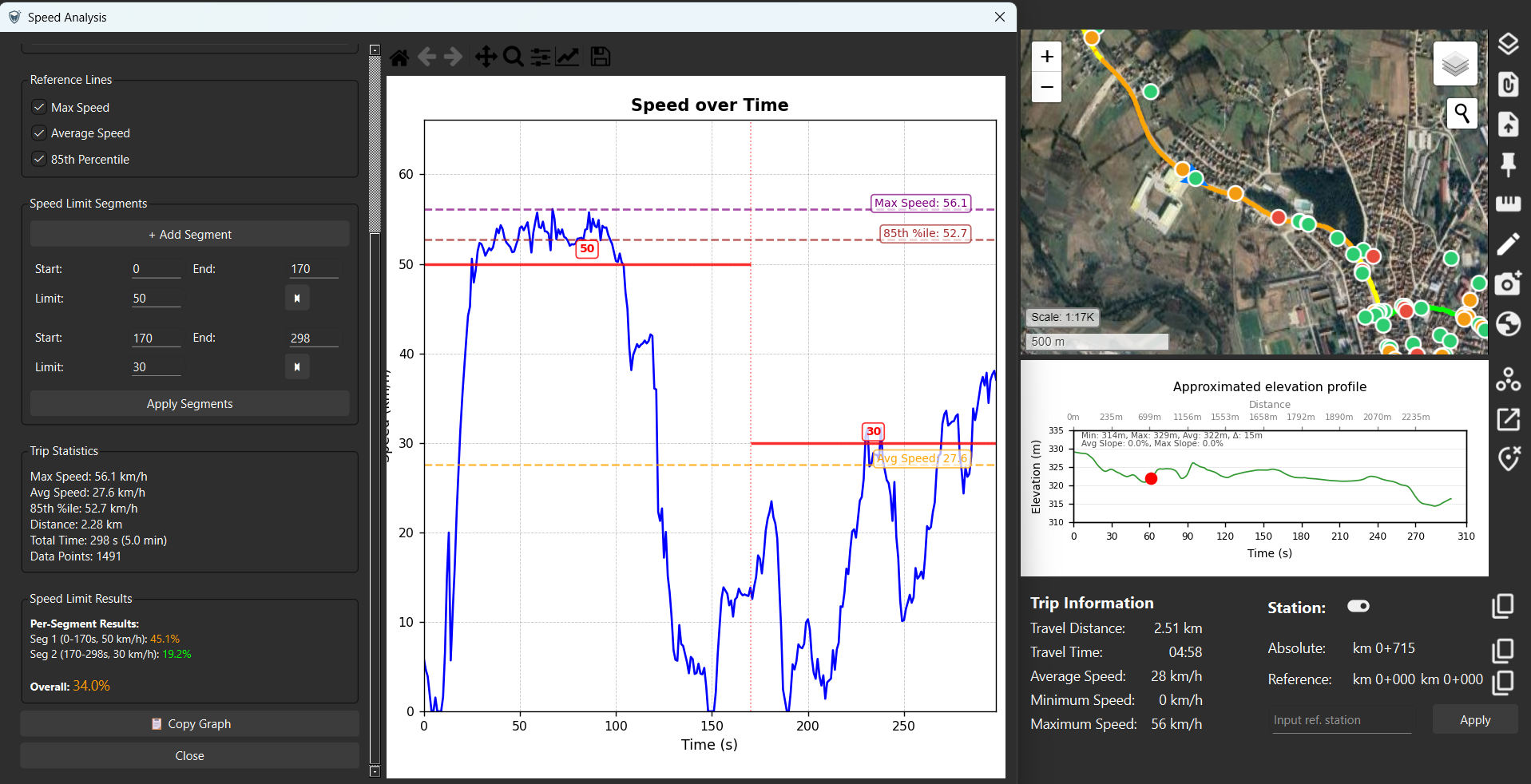
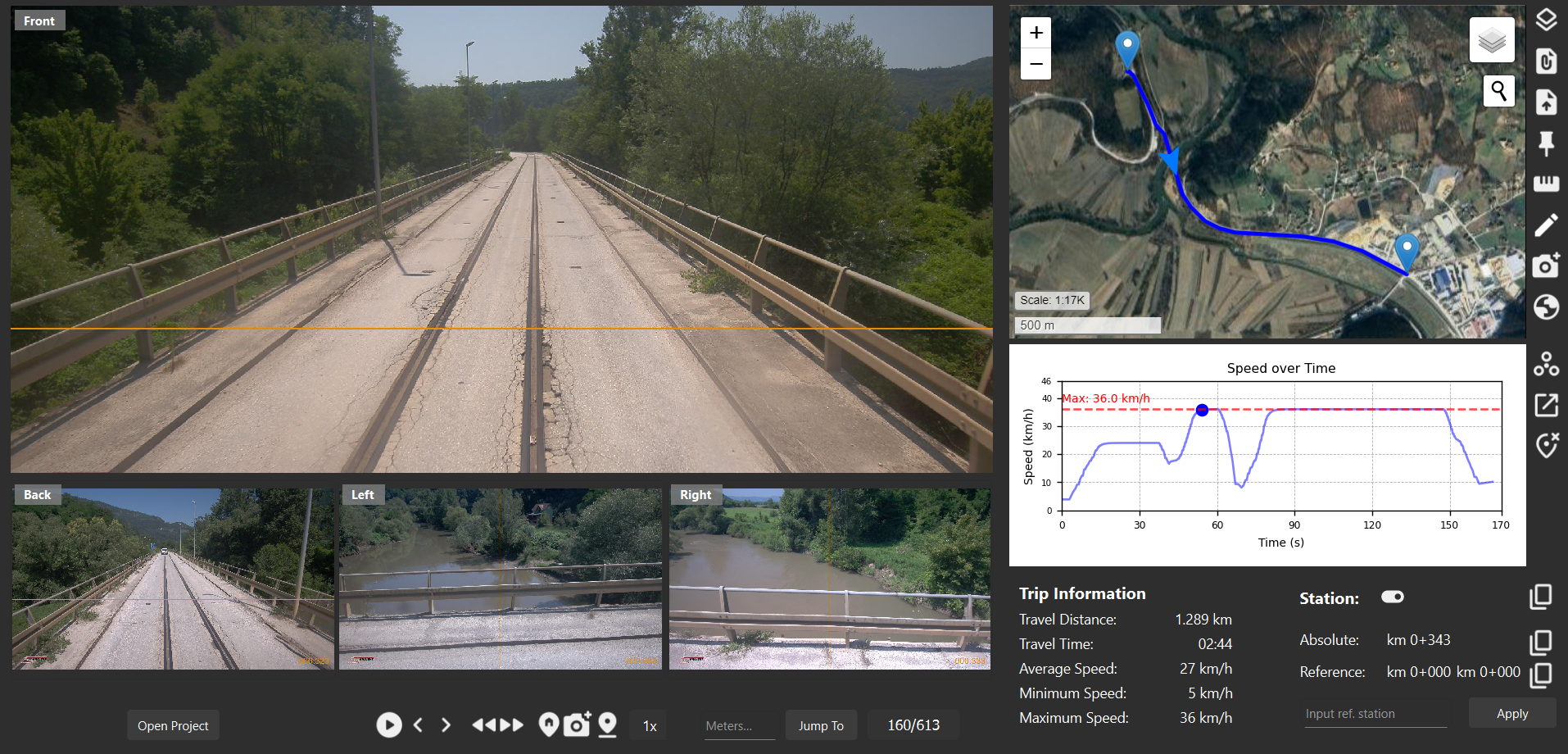
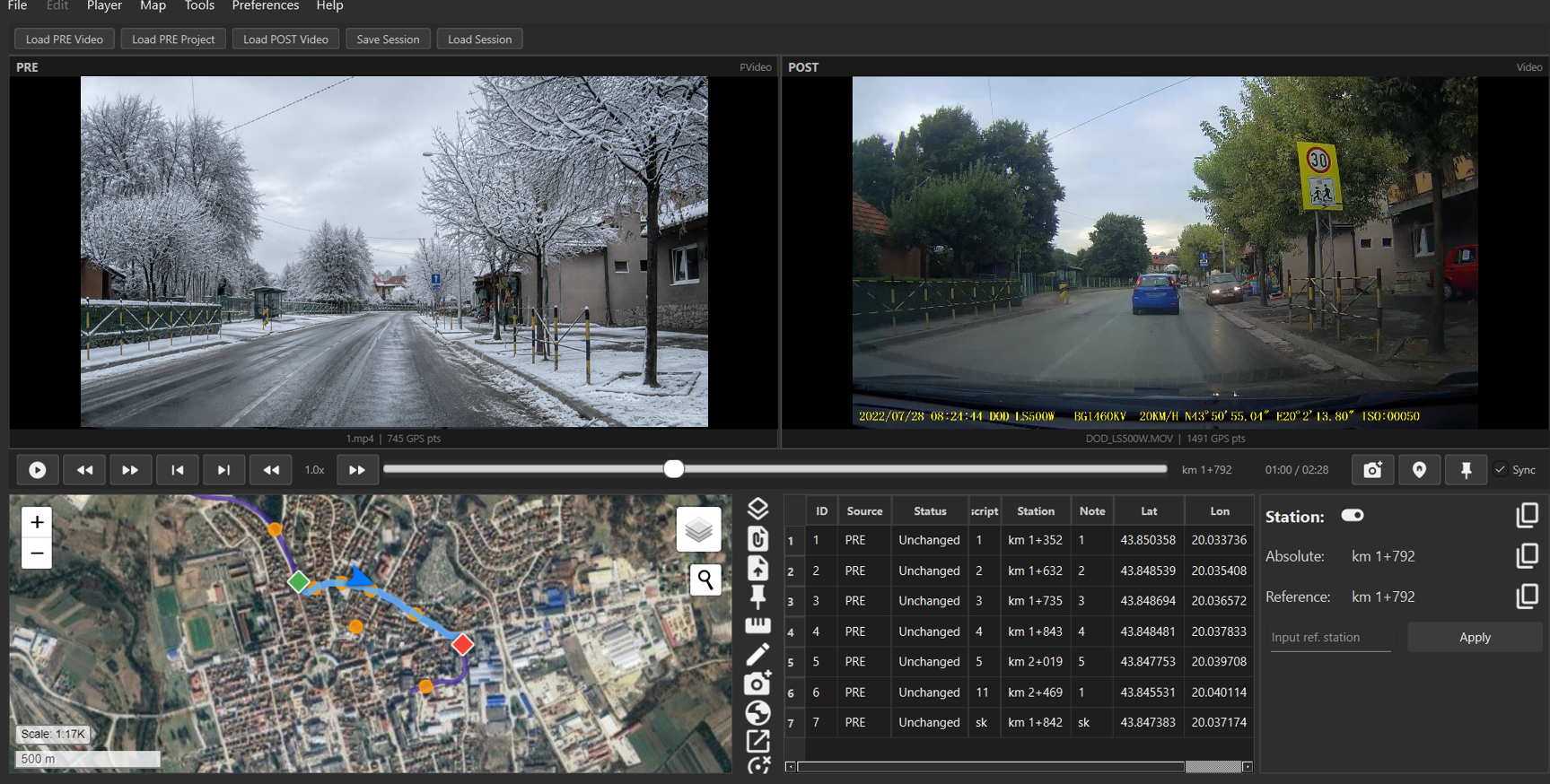
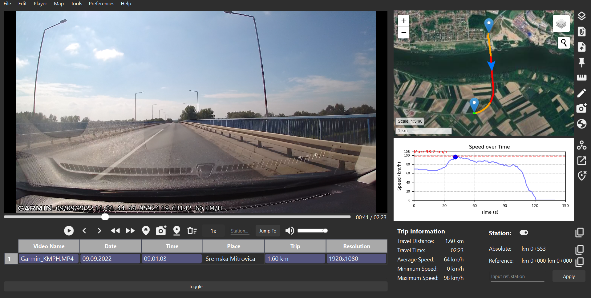
Choose Your Work Mode

Adapt RSI Viewer to different road safety inspection workflows with Standard Player, Multi-Camera System, and Pre/Post Analysis modes. Review single dashcam recordings, synchronized multi-camera surveys, or before-and-after road sections within one consistent analytical environment.

RSI Viewer work mode selection interface showing standard, multi-camera, and Pre/Post Analysis modes

Real-Time Map & Video Sync

See your routes come alive as you replay your footage. RSI Viewer synchronizes every second of your dashcam video with an interactive map, displaying your vehicle's position, speed, and direction in real time. Switch between standard and satellite views for a complete picture of your journey. With support for a large number of dashcam models, and multi-camera systems, RSI Viewer ensures seamless performance for any inspection setup. Map is compatible with kml, kmz, and gpx file imports, as well as exports.

Real-time synchronization of dashcam video playback with GPS data displayed on interactive map, showing vehicle position, speed, and route visualization for road safety inspections

Detailed Trip Insights & Stationing

Turn raw video data into meaningful analytics. RSI Viewer automatically calculates distance traveled and provides precise stationing, allowing you to define a reference point and instantly view recalculated station values. For micro-level accuracy, users can position a reference line to mark exact distances along the video frame. Combined with speed graphs and elevation profiles, this data helps engineers better understand route characteristics.

RSI Viewer stationing feature showing precise distance calculations, reference point positioning, and synchronized video frame with station values for accurate road safety audit documentation

Smart Markers & Professional Export

Mark, organize, and return to key moments effortlessly. Drop marker pins anywhere on the route or map, categorize them as safety deficiencies or points of interest, and instantly jump back to that exact moment in the footage. All markers appear in both map and list views, streamlining your workflow. Export data directly for use in Road Safety Audits (RSA), Road Safety Inspections (RSI), or other professional documentation.

Smart marker system in RSI Viewer showing categorized pins for safety deficiencies and points of interest on interactive map, enabling efficient road safety inspection documentation and reporting

In-Depth Speed Analysis

Compare recorded vehicle speeds with road speed limits to identify sections where traffic flow exceeds the permitted speed. Import accident datasets and visualize nearby crashes within a route buffer to support evidence-based road safety analysis.

RSI Viewer speed analysis interface showing vehicle speed, speed limits, and crash data near the route

Multi-Camera System

Import .cpf files from multi-camera systems and analyze synchronized video views together with GPS data, interactive maps, markers, speed profiles, and professional export workflows.

RSI Viewer multi-camera analysis interface with synchronized video views and map data

Pre/Post Analysis

Compare a previously inspected road section with a later recording of the same location to evaluate implemented safety measures, document infrastructure changes, and support follow-up road safety assessments.

RSI Viewer Pre/Post Analysis interface comparing the same road section over time
Road Safety Excellence

Enhance your road safety inspections with RSI Viewer

Unlock your road safety potential with RSI Viewer, which provides advanced tools that simplify analysis and enhance decision-making in order to elevate your inspection or audit process. Learn more about our services or contact us for custom solutions tailored to your needs.

Choose Your Plan

Plan that perfectly suits your road safety needs

Discover plans tailored to your road safety workflow. Choose a plan that aligns with your organization's goals.

RSI Viewer

Essential road safety tool for professional inspections, audits and analysis.

On request
  • Real-Time Map & Video Sync
  • Comprehensive Trip Analysis, Stationing Tools, and Intelligent Marker System
  • Supports all major dashcam brands, multiple camera systems and Pre/Post Analysis
  • RSI Checklists and Accident dataset analysis
  • Symbiosis with CAD & Google Earth Pro
We've Got You Covered

Frequently Asked Questions

Yes, as long as your dashcam records GPS data either in the video metadata or in a separate GPS file. RSI Viewer has been tested with Garmin, DOD, MIO, and 70mai dashcams, but it should also work with GPS dashcams from other manufacturers.

Please contact us — we will work to add support for your device. If we are unable to, we offer a 100% money-back guarantee within 15 business days.

No. We rely on human expertise and judgment to recognize issues that AI cannot reliably identify.

No. Active internet access is required due to live map and GPS data usage.